Mapping the Level of Macrobenthic Diversity to Evaluate Environmental and Ecosystem Disturbances

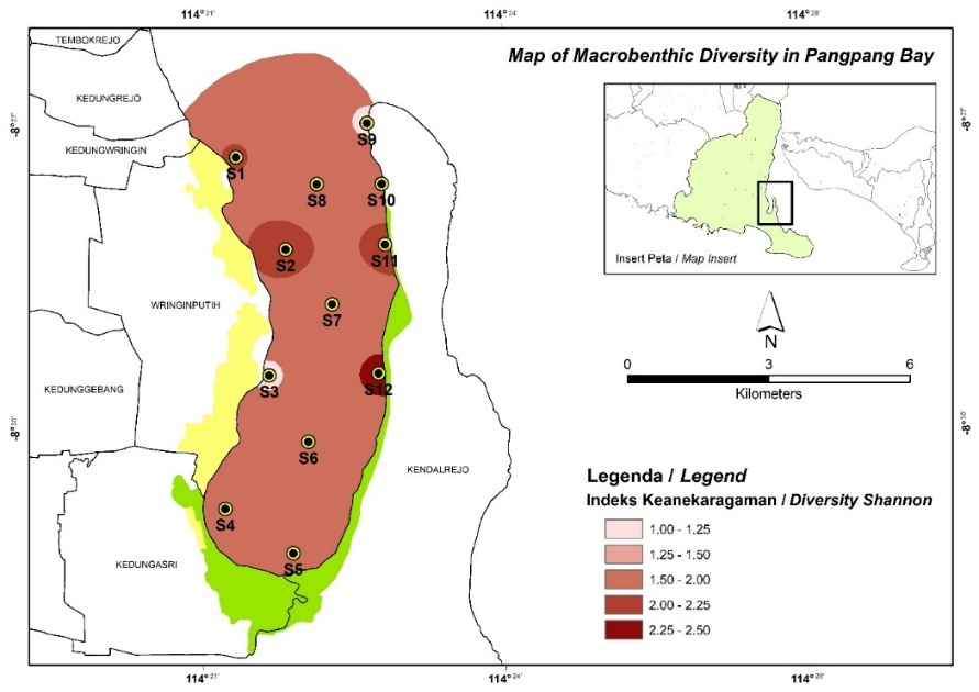
Pangpang Bay is used by the local community for aquaculture, traditional fishing and crabbing, drift net cage farming, and ecotourism. Macrobenthos, as key organisms in the food web and bioindicators of pollution due to their sessile nature and varying adaptability, were studied to assess the bay’s ecological health. This research aimed to map macrobenthic diversity (Shannon-Wiener Diversity Index, Evenness Index, and Simpson Dominance Index) to evaluate environmental disturbance levels. This research was conducted from June to July 2025. Using purposive sampling, twelve observation stations were established across the bay, from the periphery to the central zone. Data were analyzed descriptively and visualized spatially via GIS (ArcGIS). This study recorded 33 macrobenthic species representing four classes and 25 families. Species richness varied considerably among stations, ranging from 5 species (Stations 5 and 9) to 22 species (Station 12). Results showed moderate pollution levels: Shannon-Wiener Index (1.0 ≤ H’ ≤ 3.0) indicated intermediate diversity, consistent with moderately polluted waters. The Evenness Index (e ≈ 1) revealed high uniformity, with no dominant species, suggesting balanced species distribution. Similarly, the Simpson Dominance Index (D ≈ 0) confirmed the absence of dominance, aligning with high evenness. Overall, the study classifies Pangpang Bay as moderately polluted based on macrobenthic indices, highlighting the need for sustainable management to mitigate further degradation.
Copyright (c) 2025 Shinta Hiflina Yuniari, Akbar Sandi Wijaya, Agus Fani Faisol

This work is licensed under a Creative Commons Attribution-NonCommercial-ShareAlike 4.0 International License.