

Date Log
Copyright (c) 2025 Jurnal Ilmiah Perikanan dan Kelautan

This work is licensed under a Creative Commons Attribution-NonCommercial-ShareAlike 4.0 International License.
1. Copyright of the article is transferred to the journal, by the knowledge of the author, whilst the moral right of the publication belongs to the author.
2. The legal formal aspect of journal publication accessibility refers to Creative Commons Atribusi-Non Commercial-Share alike (CC BY-NC-SA), (https://creativecommons.org/licenses/by-nc-sa/4.0/)
3. The articles published in the journal are open access and can be used for non-commercial purposes. Other than the aims mentioned above, the editorial board is not responsible for copyright violation
The manuscript authentic and copyright statement submission can be downloaded ON THIS FORM.
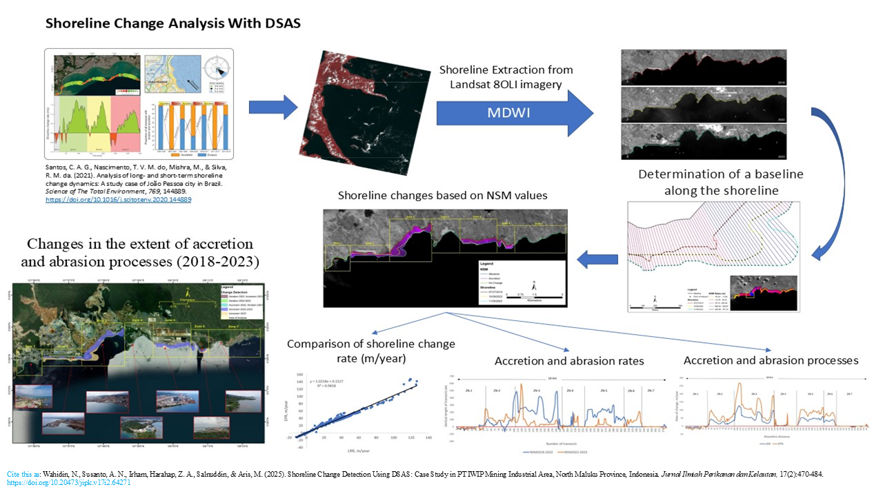
Shoreline Change Detection Using DSAS: Case Study in PT IWIP Mining Industrial Area, North Maluku Province, Indonesia

Corresponding Author(s) : Nurhalis Wahidin
Jurnal Ilmiah Perikanan dan Kelautan, Vol. 17 No. 2 (2025): JURNAL ILMIAH PERIKANAN DAN KELAUTAN
Abstract
Graphical Abstract
Highlight Research
- DSAS based on geographic information systems has the ability to extract important information on the dynamics of shoreline changes, both accretion and abrasion.
- The dynamics of shoreline change in the short period of time 2018-2023 in the IWIP industrial area shows a very dynamic change process dominated by accretion.
- The conversion of beach into land was more prevalent than the process of shoreline retreat in the study area.
- The abrasion rate in this study area was categorized as moderate, while the accretion rate was categorized as very high due to construction activities.
Abstract
The development of industrial estate infrastructure in coastal areas causes significant changes in coastal morphology. Despite extensive infrastructure development in coastal zones, limited empirical data exists on the shoreline dynamics of newly established industrial estates, particularly in Eastern Indonesia, thus highlighting the urgency of this study. This study investigates coastal morphology changes in the PT Indonesia Weda Bay Industrial Park (IWIP) industrial area over five years using Landsat 8 OLI level 2A satellite imagery and geospatial analysis. Shoreline extraction was performed using the Normalized Difference Water Index (NDWI) algorithm and analyzed with the Digital Shoreline Analysis System (DSAS) applying the Net Shoreline Movement (NSM), End Point Rate (EPR), and Linear Regression Rate (LRR) methods. The findings show that from 2018 to 2023, the shoreline in the PT IWIP area predominantly experienced accretion. The highest rate of shoreline accretion occurred in industrial zone, with a maximum of 147.58 m/year and an average of 36.56 m/year, while residential zones in the eastern and western regions experienced moderate abrasion, with a maximum of 12.32 m/year and an average of 4.11 m/year. Categorization followed standard DSAS criteria, where shoreline changes between 10–30 m/year were considered moderate, and changes above 30 m/year were classified as very high. Measurement accuracy was validated using high-resolution Google Earth imagery and Landsat metadata, ensuring positional accuracy within ±30 meters. These results highlight the rapid and spatially varied shoreline changes driven by industrial activities, emphasizing the importance of remote sensing in monitoring and managing coastal development impacts
Keywords
Download Citation
Endnote/Zotero/Mendeley (RIS)BibTeX
- Abdul, B., & Putri, M. R. (2013). Water masscharacteristics Ofweda Bay, Halmahera Island, North Maluku. Jurnal Ilmu dan Teknologi Kelautan Tropis, 5(2):365-376.
- Al-Hatrushi, S. M. (2013). Monitoring of the shoreline change using remote sensing and GIS: A case study of Al Hawasnah tidal inlet, Al Batinah Coast, Sultanate of Oman. Arabian Journal of Geosciences, 6(5):1479-1484.
- Appeaning, A. K., Jayson-Quashigah, P. N., & Kufogbe, S. (2011 ). Quantitative analysis of shoreline change using medium resolution satellite imagery in Keta, Ghana. Marine Sciences, 1(1):1-9.
- Armenio, E., De Serio, F., Mossa, M., & Petrillo, A. F. (2019). Coastline evolution based on statistical analysis and modeling. Natural Hazards and Earth System Sciences, 19(9):1937-1953.
- Barrantes-Castillo, G., & Ortega-Otárola, K. (2023). Coastal erosion and accretion on the Caribbean coastline of Costa Rica long-term observations. Journal of South American Earth Sciences, 127(7):1-14.
- Boak, E. H., & Turner, I. L. (2005). Shoreline definition and detection: A review. Journal of coastal research, 21(4):688-703.
- Burningham, H., & French, J. (2017). Understanding coastal change using shoreline trend analysis supported by cluster-based segmentation. Geomorphology, 282(2017):131-149.
- Dey, M., Sakthivel, S. P., & Jena, B. (2021). A shoreline change detection (2012-2021) and forecasting using digital shoreline analysis system (DSAS) tool: A case study of Dahej Coast, Gulf of Khambhat, Gujarat, India. Indonesian Journal of Geography, 53(2):295-309.
- Esmail, M., Mahmod, W. E., & Fath, H. (2019). Assessment and prediction of shoreline change using multi-temporal satellite images and statistics: Case study of Damietta Coast, Egypt. Applied Ocean Research, 82(2019):274-282.
- Fisher, A., Flood, N., & Danaher, T. (2016). Comparing landsat water index methods for automated water classification in eastern Australia. Remote Sensing of Environment, 175(2016):167-182.
- Fuad, M. A. Z., & Fais, D. A. M. (2017). Automatic detection of decadal shoreline change on Northern Coastal of Gresik, East Java – Indonesia. IOP Conference Series: Earth and Environmental Science, 98(1):1-11.
- Hastuti, A. W., Nagai, M., Ismail, N. P., Priyono, B., Suniada, K. I., & Wijaya, A. (2024). Spatiotemporal analysis of shoreline change trends and adaptation in Bali Province, Indonesia. Regional Studies in Marine Science, 76(8):1-15.
- Himmelstoss, E. A., Henderson, R. E., Kratzmann, M. G., & Farris, A. S. (2018). Digital shoreline analysis system (DSAS) version 5.0 user guide [Report](2018-1179). (Open-File Report, Issue. U. S. G. Survey.
- Hui, F., Xu, B., Huang, H., Yu, Q., & Gong, P. (2008). Modelling spatial‐temporal change of Poyang Lake using multitemporal Landsat imagery. International Journal of Remote Sensing, 29(20):5767-5784.
- Joesidawati, M. I., & Suntoyo. (2016). Shoreline change in Tuban District, East Java using geospatial and digital shoreline analysis system (DSAS) techniques. International Journal of Oceans and Oceanography, 10(2):235-246.
- Jonah, F. E., Adjei-Boateng, D., Agbo, N. W., Mensah, E. A., & Edziyie, R. E. (2015). Assessment of sand and stone mining along the coastline of Cape Coast, Ghana. Annals of GIS, 21(3):223-231.
- Kanwal, S., Ding, X., Sajjad, M., & Abbas, S. (2020). Three decades of coastal changes in Sindh, Pakistan (1989–2018): A geospatial assessment. Remote Sensing, 12(1):1-24.
- Kumar Das, S., Sajan, B., Ojha, C., & Soren, S. (2021). Shoreline change behavior study of Jambudwip Island of Indian Sundarban using DSAS model. The Egyptian Journal of Remote Sensing and Space Science, 24(2):961-970.
- Liew, M., Xiao, M., Jones, B. M., Farquharson, L. M., & Romanovsky, V. E. (2020). Prevention and control measures for coastal erosion in northern high-latitude communities: A systematic review based on Alaskan case studies. Environmental Research Letters, 15(9):1-22.
- Liu, H., & Jezek, K. C. (2004). Automated extraction of coastline from satellite imagery by integrating canny edge detection and locally adaptive thresholding methods. International Journal of Remote Sensing, 25(5):937-958.
- Louati, M., Saïdi, H., & Zargouni, F. (2015). Shoreline change assessment using remote sensing and GIS techniques: A case study of the Medjerda Delta Coast, Tunisia. Arabian Journal of Geosciences, 8(6):4239-4255.
- Mahapatra, M., Ratheesh, R., & Rajawat, A. S. (2014). Shoreline change analysis along the coast of South Gujarat, India, using digital shoreline analysis system. Journal of the Indian Society of Remote Sensing, 42(4):869-876.
- Maiti, S., & Bhattacharya, A. K. (2009). Shoreline change analysis and its application to prediction: A remote sensing and statistics based approach. Marine Geology, 257(1):11-23.
- Mani Murali, R., Ankita, M., Amrita, S., & Vethamony, P. (2013). Coastal vulnerability assessment of Puducherry coast, India, using the analytical hierarchical process. Natural Hazards and Earth System Sciences, 13(12):3291-3311.
- Mujabar, P. S., & Chandrasekar, N. (2013). Shoreline change analysis along the coast between Kanyakumari and Tuticorin of India using remote sensing and GIS. Arabian Journal of Geosciences, 6(3):647-664.
- Nassar, K., Fath, H., Mahmod, W. E., Masria, A., Nadaoka, K., & Negm, A. (2018). Automatic detection of shoreline change: Case of North Sinai Coast, Egypt. Journal of Coastal Conservation, 22(6):1057-1083.
- Nassar, K., Mahmod, W. E., Fath, H., Masria, A., Nadaoka, K., & Negm, A. (2019). Shoreline change detection using DSAS technique: Case of North Sinai Coast, Egypt. Marine Georesources & Geotechnology, 37(1):81-95.
- Natesan, U., Thulasiraman, N., Deepthi, K., & Kathiravan, K. (2013). Shoreline change analysis of Vedaranyam coast, Tamil Nadu, India. Environ Monit Assess, 185(6):5099-5109.
- Pajak, M. J., & Leatherman, S. P. (2002). The high water line as shoreline indicator. Journal of coastal research, 18(2):329-337.
- Quang, D., Ngan, V., Ho, T., Viet, N., Tinh, N., & Tanaka, H. (2021). Long-term shoreline evolution using DSAS technique: A case study of Quang Nam Province, Vietnam. Journal of Marine Science and Engineering, 9(10):1-18.
- Romine, B., Fletcher, C., Frazer, N., Genz, A., Barbee, M., & Lim, S.-C. (2009). Historical shoreline change, Southeast Oahu, Hawaii; Applying polynomial models to calculate shoreline change rates. Journal of Coastal Research Journal of Coastal Research, 25(2):1236-1253.
- Sebat, M., & Salloum, J. (2018). Estimate the rate of shoreline change using the statistical analysis technique (EPR). Bit Numerical Mathematics, 1(2018):59-65.
- Sekar, L. G., Androws, X., Annaidasan, K., Kumar, A., Kannan, R., Muthusankar, G., & Balasubramani, K. (2024). Assessment of shoreline changes and associated erosion and accretion pattern in coastal watersheds of Tamil Nadu, India. Natural Hazards Research, 4(2):231-238.
- Sheik, M., & Chandrasekar. (2011). A shoreline change analysis along the coast between Kanyakumari and Tuticorin, India, using digital shoreline analysis system. Geo-Spatial Information Science, 14(4):282-293.
- Song, Y., Shen, Y., Xie, R., & Li, J. (2021). A DSAS-based study of central shoreline change in Jiangsu over 45 years. Anthropocene Coasts, 4(1):115-128.
- Sui, L., Wang, J., Yang, X., & Wang, Z. (2020). Spatial-temporal characteristics of coastline changes in Indonesia from 1990 to 2018. Sustainability, 12(8):1-28.
- Sutikno, S., Sandhyavitri, A., Haidar, M., & Yamamoto, K. (2017). Shoreline change analysis of Peat Soil Beach in Bengkalis Island based on GIS and RS. International journal of engineering and technology, 9(3):233-238.
- Thieler, E. R., Himmelstoss, E. A., Zichichi, J. L., & Ergul, A. (2009). The digital shoreline analysis system (DSAS) Version 4.0 - An ArcGIS extension for calculating shoreline change [Report](2008-1278). (Open-File Report, Issue. U. S. G. Survey.
- Xu, H. (2006). Modification of normalised difference water index (NDWI) to enhance open water features in remotely sensed imagery. International Journal of Remote Sensing, 27(14):3025-3033.
- Zhao, B., Guo, H., Yan, Y., Wang, Q., & Li, B. (2008). A simple waterline approach for tidelands using multi-temporal satellite images: A case study in the Yangtze Delta. Estuarine, Coastal and Shelf Science, 77(1):134-142.
- Zhou, M., Wu, M., Zhang, G., Zhao, L., Hou, X., & Yang, Y. (2019). Analysis of coastal zone data of Northern Yantai collected by remote sensing from 1990 to 2018. Applied Sciences, 9(20):1-20.
References
Abdul, B., & Putri, M. R. (2013). Water masscharacteristics Ofweda Bay, Halmahera Island, North Maluku. Jurnal Ilmu dan Teknologi Kelautan Tropis, 5(2):365-376.
Al-Hatrushi, S. M. (2013). Monitoring of the shoreline change using remote sensing and GIS: A case study of Al Hawasnah tidal inlet, Al Batinah Coast, Sultanate of Oman. Arabian Journal of Geosciences, 6(5):1479-1484.
Appeaning, A. K., Jayson-Quashigah, P. N., & Kufogbe, S. (2011 ). Quantitative analysis of shoreline change using medium resolution satellite imagery in Keta, Ghana. Marine Sciences, 1(1):1-9.
Armenio, E., De Serio, F., Mossa, M., & Petrillo, A. F. (2019). Coastline evolution based on statistical analysis and modeling. Natural Hazards and Earth System Sciences, 19(9):1937-1953.
Barrantes-Castillo, G., & Ortega-Otárola, K. (2023). Coastal erosion and accretion on the Caribbean coastline of Costa Rica long-term observations. Journal of South American Earth Sciences, 127(7):1-14.
Boak, E. H., & Turner, I. L. (2005). Shoreline definition and detection: A review. Journal of coastal research, 21(4):688-703.
Burningham, H., & French, J. (2017). Understanding coastal change using shoreline trend analysis supported by cluster-based segmentation. Geomorphology, 282(2017):131-149.
Dey, M., Sakthivel, S. P., & Jena, B. (2021). A shoreline change detection (2012-2021) and forecasting using digital shoreline analysis system (DSAS) tool: A case study of Dahej Coast, Gulf of Khambhat, Gujarat, India. Indonesian Journal of Geography, 53(2):295-309.
Esmail, M., Mahmod, W. E., & Fath, H. (2019). Assessment and prediction of shoreline change using multi-temporal satellite images and statistics: Case study of Damietta Coast, Egypt. Applied Ocean Research, 82(2019):274-282.
Fisher, A., Flood, N., & Danaher, T. (2016). Comparing landsat water index methods for automated water classification in eastern Australia. Remote Sensing of Environment, 175(2016):167-182.
Fuad, M. A. Z., & Fais, D. A. M. (2017). Automatic detection of decadal shoreline change on Northern Coastal of Gresik, East Java – Indonesia. IOP Conference Series: Earth and Environmental Science, 98(1):1-11.
Hastuti, A. W., Nagai, M., Ismail, N. P., Priyono, B., Suniada, K. I., & Wijaya, A. (2024). Spatiotemporal analysis of shoreline change trends and adaptation in Bali Province, Indonesia. Regional Studies in Marine Science, 76(8):1-15.
Himmelstoss, E. A., Henderson, R. E., Kratzmann, M. G., & Farris, A. S. (2018). Digital shoreline analysis system (DSAS) version 5.0 user guide [Report](2018-1179). (Open-File Report, Issue. U. S. G. Survey.
Hui, F., Xu, B., Huang, H., Yu, Q., & Gong, P. (2008). Modelling spatial‐temporal change of Poyang Lake using multitemporal Landsat imagery. International Journal of Remote Sensing, 29(20):5767-5784.
Joesidawati, M. I., & Suntoyo. (2016). Shoreline change in Tuban District, East Java using geospatial and digital shoreline analysis system (DSAS) techniques. International Journal of Oceans and Oceanography, 10(2):235-246.
Jonah, F. E., Adjei-Boateng, D., Agbo, N. W., Mensah, E. A., & Edziyie, R. E. (2015). Assessment of sand and stone mining along the coastline of Cape Coast, Ghana. Annals of GIS, 21(3):223-231.
Kanwal, S., Ding, X., Sajjad, M., & Abbas, S. (2020). Three decades of coastal changes in Sindh, Pakistan (1989–2018): A geospatial assessment. Remote Sensing, 12(1):1-24.
Kumar Das, S., Sajan, B., Ojha, C., & Soren, S. (2021). Shoreline change behavior study of Jambudwip Island of Indian Sundarban using DSAS model. The Egyptian Journal of Remote Sensing and Space Science, 24(2):961-970.
Liew, M., Xiao, M., Jones, B. M., Farquharson, L. M., & Romanovsky, V. E. (2020). Prevention and control measures for coastal erosion in northern high-latitude communities: A systematic review based on Alaskan case studies. Environmental Research Letters, 15(9):1-22.
Liu, H., & Jezek, K. C. (2004). Automated extraction of coastline from satellite imagery by integrating canny edge detection and locally adaptive thresholding methods. International Journal of Remote Sensing, 25(5):937-958.
Louati, M., Saïdi, H., & Zargouni, F. (2015). Shoreline change assessment using remote sensing and GIS techniques: A case study of the Medjerda Delta Coast, Tunisia. Arabian Journal of Geosciences, 8(6):4239-4255.
Mahapatra, M., Ratheesh, R., & Rajawat, A. S. (2014). Shoreline change analysis along the coast of South Gujarat, India, using digital shoreline analysis system. Journal of the Indian Society of Remote Sensing, 42(4):869-876.
Maiti, S., & Bhattacharya, A. K. (2009). Shoreline change analysis and its application to prediction: A remote sensing and statistics based approach. Marine Geology, 257(1):11-23.
Mani Murali, R., Ankita, M., Amrita, S., & Vethamony, P. (2013). Coastal vulnerability assessment of Puducherry coast, India, using the analytical hierarchical process. Natural Hazards and Earth System Sciences, 13(12):3291-3311.
Mujabar, P. S., & Chandrasekar, N. (2013). Shoreline change analysis along the coast between Kanyakumari and Tuticorin of India using remote sensing and GIS. Arabian Journal of Geosciences, 6(3):647-664.
Nassar, K., Fath, H., Mahmod, W. E., Masria, A., Nadaoka, K., & Negm, A. (2018). Automatic detection of shoreline change: Case of North Sinai Coast, Egypt. Journal of Coastal Conservation, 22(6):1057-1083.
Nassar, K., Mahmod, W. E., Fath, H., Masria, A., Nadaoka, K., & Negm, A. (2019). Shoreline change detection using DSAS technique: Case of North Sinai Coast, Egypt. Marine Georesources & Geotechnology, 37(1):81-95.
Natesan, U., Thulasiraman, N., Deepthi, K., & Kathiravan, K. (2013). Shoreline change analysis of Vedaranyam coast, Tamil Nadu, India. Environ Monit Assess, 185(6):5099-5109.
Pajak, M. J., & Leatherman, S. P. (2002). The high water line as shoreline indicator. Journal of coastal research, 18(2):329-337.
Quang, D., Ngan, V., Ho, T., Viet, N., Tinh, N., & Tanaka, H. (2021). Long-term shoreline evolution using DSAS technique: A case study of Quang Nam Province, Vietnam. Journal of Marine Science and Engineering, 9(10):1-18.
Romine, B., Fletcher, C., Frazer, N., Genz, A., Barbee, M., & Lim, S.-C. (2009). Historical shoreline change, Southeast Oahu, Hawaii; Applying polynomial models to calculate shoreline change rates. Journal of Coastal Research Journal of Coastal Research, 25(2):1236-1253.
Sebat, M., & Salloum, J. (2018). Estimate the rate of shoreline change using the statistical analysis technique (EPR). Bit Numerical Mathematics, 1(2018):59-65.
Sekar, L. G., Androws, X., Annaidasan, K., Kumar, A., Kannan, R., Muthusankar, G., & Balasubramani, K. (2024). Assessment of shoreline changes and associated erosion and accretion pattern in coastal watersheds of Tamil Nadu, India. Natural Hazards Research, 4(2):231-238.
Sheik, M., & Chandrasekar. (2011). A shoreline change analysis along the coast between Kanyakumari and Tuticorin, India, using digital shoreline analysis system. Geo-Spatial Information Science, 14(4):282-293.
Song, Y., Shen, Y., Xie, R., & Li, J. (2021). A DSAS-based study of central shoreline change in Jiangsu over 45 years. Anthropocene Coasts, 4(1):115-128.
Sui, L., Wang, J., Yang, X., & Wang, Z. (2020). Spatial-temporal characteristics of coastline changes in Indonesia from 1990 to 2018. Sustainability, 12(8):1-28.
Sutikno, S., Sandhyavitri, A., Haidar, M., & Yamamoto, K. (2017). Shoreline change analysis of Peat Soil Beach in Bengkalis Island based on GIS and RS. International journal of engineering and technology, 9(3):233-238.
Thieler, E. R., Himmelstoss, E. A., Zichichi, J. L., & Ergul, A. (2009). The digital shoreline analysis system (DSAS) Version 4.0 - An ArcGIS extension for calculating shoreline change [Report](2008-1278). (Open-File Report, Issue. U. S. G. Survey.
Xu, H. (2006). Modification of normalised difference water index (NDWI) to enhance open water features in remotely sensed imagery. International Journal of Remote Sensing, 27(14):3025-3033.
Zhao, B., Guo, H., Yan, Y., Wang, Q., & Li, B. (2008). A simple waterline approach for tidelands using multi-temporal satellite images: A case study in the Yangtze Delta. Estuarine, Coastal and Shelf Science, 77(1):134-142.
Zhou, M., Wu, M., Zhang, G., Zhao, L., Hou, X., & Yang, Y. (2019). Analysis of coastal zone data of Northern Yantai collected by remote sensing from 1990 to 2018. Applied Sciences, 9(20):1-20.